New, delightful air has arrived to New England! A Monday night cold frontal passage shifted the wind to blow from the north, opening the door to a chunk of cooler, drier Canadian air thrust southward in the clockwise flow of air around a dome of high pressure, or fair weather, building southeast through Ontario. The north and northeast wind will…
A Monday night cold frontal passage shifted the wind to blow from the north, opening the door to a chunk of cooler, drier Canadian air thrust southward in the clockwise flow of air around a dome of high pressure, or fair weather, building southeast through Ontario. The north and northeast wind will remain fresh at 10-20 mph Monday afternoon, creating a two to four foot chop on the ocean waters.
Meanwhile, while our exclusive, First Alert 10-day forecast averages about 5-6 degrees cooler than normal for the upcoming stretch, a massive dome of heat is developing in the nation’s midsection, with Excessive Heat Warnings owing to dangerous heat index values up to 115 degrees from Texas and Louisiana all the way north to Minnesota and Wisconsin! Not only is our flow of cool air from Canada protecting New England from that heat, but also from an increasingly busy Tropical Atlantic – at least...
The biggest concern for New England during this annual peak in tropical activity is if a southerly wind flow develops through the atmosphere, opening the door for storms to move north from the Atlantic, but that doesn’t appear to be the setup for us over the next 10 days, thanks to recurring cold fronts that are the product of northern jet stream disturbances.
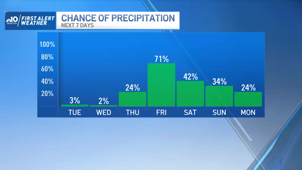
Depending on the intensity and timing of the rain, a First Alert may be needed for impact from the rain Friday – there’s also the chance thunderstorms could grow strong in Southern New England as humid air makes a brief comeback on an increasing southerly wind. Even Saturday enough moisture will linger in the air – evident by a continued humid feeling – for passing disturbances aloft to touch off scattered showers or thunder, especially during the afternoon.
The chance of showers drops Sunday though isn’t zero – it’s still possible a shower sneaks back into the forecast, though that isn’t our expectation at this point – then the chance of showers looks low next week, even as what is likely to be Hurricane Franklin passes near or over Bermuda, trucking north but likely to turn northeast while still safely to our southeast.
Belgique Dernières Nouvelles, Belgique Actualités
Similar News:Vous pouvez également lire des articles d'actualité similaires à celui-ci que nous avons collectés auprès d'autres sources d'information.
 Chelsea reach transfer agreement with New England for PetrovicChelsea have reached an agreement with New England Revolution for the signing of goalkeeper Djordje Petrovic, sources tell The Athletic. The Premier League side have agreed a fee worth €16million (£13.6m, $17.4m) plus €2m in add-ons for the 23-year-old. Petrovic is now expected to undergo a medical and sign for the west London club in the coming days. Follow the summer transfer window with The Athletic… Transfer news — live updates Premier League done deals Daily Football Briefing podcast — your 10-minute lowdown The Serbian is regarded as the best goalkeeper in MLS. The...
Lire la suite »